Indonesian Mount Semeru spews hot clouds as far as seven kilometers
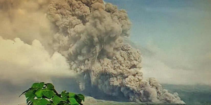
Indonesian Mount Semeru has been spewing avalanches of hot clouds since early morning on Sunday with gray columns and medium intensity.
Jakarta (Indonesia Window) – Indonesian Mount Semeru has again spewed avalanches of hot clouds on Sunday since 2.46 a.m. local time with gray columns and medium intensity to the southeast and the south as high as approximately 1,500 meters above the summit.
.jpg)
The eruption activity of Indonesian Mount Semeru was recorded on a seismograph with a maximum amplitude of 35 mm and a duration of 0 seconds, Abdul Muhari, Acting Head of the Data, Information and Communication Center of the Indonesian National Agency for Disaster Countermeasure (BNPB), said in his official statement on Sunday.
According to the Geological Agency of the Center for Volcanology and Geological Hazard Mitigation of the Indonesian Ministry of Energy and Mineral Resources, the source of the avalanches of the hot clouds came from piles at the tip of the lava tongue which is about 800 meters from the peak or Jonggring Seloko Crater.
Based on the monitoring of the CCTV (monitor camera) for Semeru, the avalanches of hot clouds phenomenon continued until this morning at 7.42 a.m. local time with sliding distances varying from five to seven kilometers. At the time this press release was made, the avalanches of hot clouds phenomenon of the volcano were still ongoing.
In anticipation of the risk impact of the avalanches of the hot clouds,
the Lumajang District Disaster Management Agency (BPBD) team went to the field for a quick assessment.
“We are already at the monitoring post. The avalanches of the hot clouds are currently still ongoing at a distance of between five and seven kilometers. Our monitoring post is approximately 12 kilometers from the summit,” the agency’s head Joko Sambang explained.
Joko added that based on observations in the field with the team of the Data, Information and Communication Center, volcanic ash is seen rising high and tending to go to the south.
In anticipation of the impact of the risk of volcanic ash, the Lumajang District Disaster Management Agency team also distributed free masks to local people.
“The volcanic ash is heading south, to Rowo Baung area in Pronojiwo sub district, Lumajang district, East Java province. There, friends have distributed masks and provided outreach to the community,” Joko said.
The Center for Volcanology and Geological Hazard Mitigation also called on all people not to carry out activities and stay away from the southeastern sector as far as 13 km from the peak.
Outside of this distance, local people are urged not to carry out activities at a distance of 500 meters from the riverbank of Besuk Kobokan because it has the potential to be affected by expansion of hot clouds and lava flows up to a distance of 17 km from the summit.
In addition, the people are also prohibited from doing activities within a five km radius of the crater of Mount Semeru because it is prone to the danger of throwing stones (incandescent).
The people are expected to always be aware of the potential for avalanches of hot clouds and lava along rivers or valleys that disgorge at the peak of the Semeru volcano.
Due to the avalanches of the hot clouds, the Center for Volcanology and Geological Hazard Mitigation still sets the status of ‘standby’ or level III for Mount Semeru.
Reporting by Indonesia Window

Indonesia to see ASEAN resilient, become barometer for cooperation

Indonesia’s foreign debt falls 5.9 bln USD as of November 2021

Indonesia wins Brunei’s commitment of 450 mln USD for new capital development

No diplomatic note regarding Habib Rizieq: Ambassador